Hill Country could see ‘significant’ mid-week rain

National Weather Service
Staff Reports
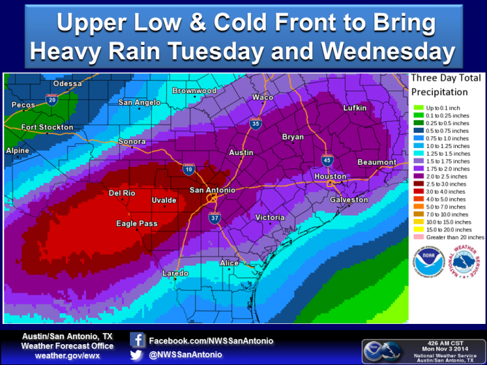
Meteorologists are predicting “significant” amounts of rain in the Hill Country and South Central Texas during a rain event from the afternoon of Tuesday, Nov. 4, into Wednesday afternoon, and possibly even into late-week.
“Widespread and significant rains will develop across the region... significant rain totals are forecast,” according to Bob Rose on the Weather (Oct. 31), the blog of Lower Colorado River Authority meteorologist Bob Rose.
The National Weather Service also predicts heavy rainfall and associated hazards.
“Locally heavy rains of 1-3 inches, with isolated totals of 4-5 inches” are possible, according to Paul Yura, meteorologist with the NWS in Austin and San Antonio region.
People can expect “strong thunderstorms with dangerous lightning and high wind gusts,” Yura said. “High rain rates, in excess of 1-2 inches of rain per hour” add to the danger of flash flooding because of “increased flows on creeks and low water crossings.”
There are two major causes for the weather system.
A cold front moving into the region Tuesday will combine with an “upper level storm system and cold front combined with increasing moisture from the Gulf of Mexico and the eastern Pacific,” according to the NWS.
Rose’s blog adds that the moisture in the Gulf of Mexico is largely thanks to Hurricane Vance.
“The front is forecast to weaken Thursday while light to moderate rains continue across the entire region,” Rose said. Rain showers could “continue into early Friday before the trough of low pressure finally exits to the east.”
The NWS constantly updates its forecasts as well as watches, warnings and advisories for the region at: www.weather.gov/austin

