
Aquifers, lakes replenished
ALEXANDRIA RANDOLPH/HIGHLAND LAKES NEWSPAPERS
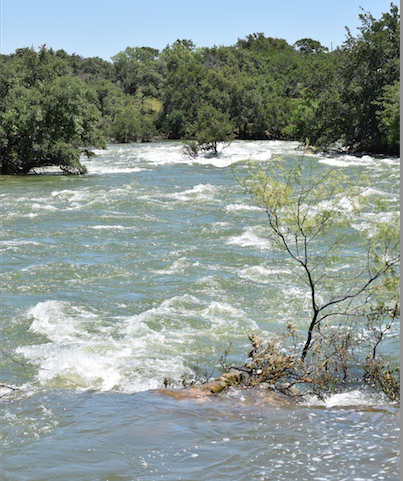
Lake Buchanan just south of the Buchanan Dam churns and caps white with fast moving water – the floodgates are open after heavy rainfall in recent weeks. Visit The-Highlander on Facebook for maps of local aquifers: bit.ly/1MZW51U
By Alexandria Randolph
Highland Lakes Newspapers
Local officials have confirmed: our lakes and aquifers are full.
As meteorologists predicted, the spring of 2016 has been a wet one, and rainfalls in the past few months, including flooding across central Texas in April, May and early June have led to higher lake levels than have been experienced in years, and the replenishing of Burnet County aquifers, water officials said this week.
Central Texas Groundwater Conservation District Manager Charles Shell said Wednesday that all the aquifers under Burnet County are full.
“The aquifers are all full and the springs are running,” he said. “Felps Spring is running at over 95 gallons per minute. There is water pouring out of every spring there is.”
Shell said the state of water in the area was “much better than in 2011,” when aquifer and lake storage alike was suffering from a serious drought that began that year.
LAKE LEVELS
Following heavy rains in late May and early June, the Lower Colorado River Authority recorded combined lake levels at 100 percent, with an excess of 190,235 acre-feet of water compared to the 2,010,544 acre-feet Lake Buchanan and Lake Travis store when full.
Lake Buchanan's current level, recorded at noon on June 6, is 825,588 acre-feet, or 94 percent full, while Lake Travis is at 121 percent, with 1,375,611 acre-feet. LCRA Spokesperson Clara Tuma said Monday the lake is currently at 692.5 feet above mean sea level, and if it reached 693 feet, it would be closed to recreational boating.
Due to flooding upstream, LCRA officials approved the release of 38,575 acre-feet of water from Lake Buchanan, 39,089 acre-feet from Inks Lake, 66,334 acre-feet from Lake LBJ, 62,137 acre-feet from Lake Marble Falls, and 45,071 acre-feet from Lake Travis at midnight on Thursday, June 2.
AQUIFERS
According to data provided by CTGCD and the Texas Water Development Board, the Hickory, Trinity, Ellenburger-San Saba, Marble Falls, Granite, and Granite Gravel aquifers have seen drastic recharge rates since mid May.
In a report prepared by CTGCD Hydrologist Mitchell Sodek, while water in the Ellenburger-San Saba aquifer don't typically fluctuate, during the 2011-2015 drought, the aquifer saw water levels drop “as much as 30 feet in a few isolated areas, with the average well seeing five to 10 feet fluctuations,” he reported. “Maximum recorded water levels have occurred in 2016 and the aquifer has reached its 'maximum capacity' as is measured by water levels decreasing in wells shortly after heavy rainfall.” As a result, the aquifer is releasing much of the excess water to springs, seeps, and creek and river baseflow, Sodek said.
He added in his report that much like the Ellenburger aquifer, “the Marble falls aquifer responds quickly to local rainfall. There are not many wells in this aquifer, but the few in southern Burnet County have rebounded from the drought lows of about 15-20 feet.”
The Hickory aquifer on average dropped 10 feet during the drought with some wells recording up to 50 feet. In 2016 the aquifer levels have recovered to the highest levels they have been since recording began in 2010.
The Granite aquifer, rather a special case because of its fractured bedrock that easily receives rainfall and thus is highly sensitive to drought conditions, went dry in spots during the drought of recent years.
“The granite water levels are very site specific but in general, deeper wells survived the drought while shallow ones did not. All granite water levels have returned to pre drought levels or higher,” Sodek reported.
The Granite Gravel aquifer west of Marble Falls and Kingsland saw water levels drop “on average 15-20 feet during the drought but recovered in 2016 to new recorded high levels since data collection began in 2008 for this aquifer,” Sodek said.
Glen Rose layer of the Trinity aquifer provides the majority of seeps and springs in the eastern half of Burnet County, and “can be completely dry during droughts such as the one we had in 2011-2015,” Sodek said. “The North and South San Gabriel Rivers, Oatmeal Creek, and Rocky Creek all have seen healthy sustained baseflows throughout the year due to the Glen Rose formation being saturated.”
The Hensell, which provides water to a number of wells in the county, and Hosston layers of the Trinity aquifer receive some recharge in shallower wells, but on the eastern side of the county are influenced more by pumping and pressure than by rainfall.
“During the 2011-2015 drought the pumping was increased due to lack of rainfall, and the water levels dropped as much as 25 feet in (the) east and... on average 10-15 feet declines across the county,” Sodek reported. “In 2016 many of the wells have recovered to pre drought levels, but far eastern Burnet County will probably continue a downward trend due to pumping and the nature of the aquifer.”
FORECAST
According to LCRA forecast data, Buchanan lake levels should remain near full to full through November of this year if weather conditions produce high or moderate rainfall. If conditions become dry, lake levels could drop 10 feet msl (mean sea level).
Levels for Lake Travis will drop a minimum of 8 feet msl (mean sea level) if conditions do not remain wet this year, forecast data reports.
Combined storage for the lakes will drop from full (roughly 2 million acre-feet) to 1.8 million acre-feet with moderate rainfall, or, if conditions become dry, will drop to 1.6 million acre-feet based on forecast values up to November of this year.
Remember to "Like" us at The-Highlander on Facebook to see maps of local aquifers: http://bit.ly/1MZW51U