

Texas battens down as Harvey gathers speed
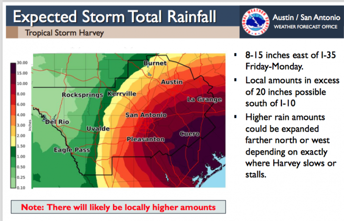
A National Weather Service map illustrates possible rainfall totals during the Hurricane Harvey event. So far, the chance for Friday night rain has continued to be listed at 30 percent for Burnet County, which can be seen in orange and yellow bands of 1-3 inches, far from the devastation faced by southern neighbors. Nonetheless, the warning is to stay vigilant in case the storm stalls or changes course.
Rather than planning one more pre-school trip to the Gulf Coast, Highland Lakes residents were tracking path of Hurricane Harvey.
The storm was elevated from Tropical Depression status Thursday, Aug. 24, expected to make landfall late Friday in between Corpus Cristi and Matagorda Bay as a Category 3 storm, with winds exceeding 110 mph, according to the National Weather Service (NWS)--the firs of that kind since Hurricane Ike in October of 2005.
It prompted the first Storm Surge Warning ever issued officially by the National Weather Service—one in effect along the Texas coast from Port Mansfield to High Island. A Storm Surge Watch is in effect from south of Port Mansfield Texas to the Mouth of the Rio Grande.
A Storm Surge Warning means there is a danger of life-threatening inundation, from rising water moving inland from the coastline, during the next 36 hours in the indicated locations. A Storm Surge Watch means there is a possibility of life-threatening inundation from rising water moving inland from the coastline in the indicated locations during the next 48 hours. For a depiction of areas at risk, see the National Weather Service Storm Surge Watch/Warning Graphic, available at www.hurricanes.gov.
“This is a life-threatening situation,” said a social media post by the NWS National Hurricane Center. “Persons located within these areas should take all necessary actions to protect life and property from rising water and the potential for other dangerous conditions. Promptly follow evacuation and other instructions from local officials.”
Llano and Burnet counties were included in the National Weather Service (NWS) alert for isolated showers and thunderstorms through the night and continuing through an event that could turn deadly for southern neighbors over the next five days.
“Only small changes to the track or forward speed of Harvey will result in large changes to impacts across South Texas,” read the alert. “The heavy rainfall threat could be expanded farther west and north with any changes.”
Horseshoe Bay took the warning to heart late Thursday, closing its campgrounds until further notice, due to their low-lying locations.
“Right now, it looks as if Burnet County may see 4-6 inches of rain,” said Joe Arellano, meteorologist-in-charge at the NWS office for Austin and San Antonio. “But it will be much worse for areas south and east of you.”
East of I-35, the NWS was forecasting 8-15 inches east of through Monday. South of I-10 amounts could exceed 20 inches, the service said, adding “higher rain amounts could be expanded farther north or west depending on exactly where Harvey slows or stalls.”
Southeastern Texas counties were being warned of a potential for 60-80 mph winds and even tornadoes, beginning most likely Friday night. The potential of 40-50 mph winds was described for areas that extend to just north of San Antonio and just south of Austin.
With threats of Damage to trees, power lines, and homes, as well as communication and power outages likely in hardest hit areas, the Pedernales Electric Cooperative (PEC) said Thursday it would deploy resources to ensure rapid response.
“Please take all necessary precautions to protect life and property,” said the PEC announcement.
The Texas Department of Public Safety (DPS) issued its own alert urging Texans along the Gulf Coast region and nearby counties to prepare for severe weather, strong winds and localized flooding through the weekend.
“If severe weather creates hazardous driving conditions, roadways will be closed for the safety of the motoring public,” said the DPS. “Citizens should stay tuned to local television and radio stations for weather and traffic updates.”
An NWS update from Jason Runyen of the weather forecast office in New Braunfels said Harvey is expected to weaken inland over South Texas over the weekend, slowing its forward speed and possibly stalling or meandering.
“A life-threatening flash flooding threat is expected along with devastating mainstem river flooding inland over portions of South Central Texas,” he said. “It should continued to be stressed that there is uncertainty with the track and speed of Harvey. Small changes to the track, intensity, and/or forward speed of Harvey will result in large changes to flooding and wind impacts across South Central Texas.
“The heavy rainfall threat could be expanded farther west and north with any of these changes.”
The name Flash Flood Alley is well earned in the Hill Country, where just a few inches of locally heavy rain can put waters over low-water crossings or turn creeks into drowning pools. The adage “Turn Around, Don't Drown” is a warning to take to heart.
If the storm makes it to hurricane status of sustained winds of 75 mph, it will be the first to make landfall in the state since Hurricane Ike in 2008.
Gulf Cost waters are even warmer than usual right now, creating an engine to strengthen Tropical Depression Harvey to hurricane status. But it won't have to be Hurricane Harvey to wreak havoc. The Houston Chronicle said the storm's slow pace that could cause it to dump more than a foot of rain in Harris County and other costal areas was being likened to Tropical Storm Allison in 2001.
Allison remained tropical or sub-tropical for more than 15 days. It dumped torrents of water on the Gulf of Mexico, on Texas, Louisiana and then across the southeastern U.S. Disaster areas were designated in 75 counties in its path. An 8-foot wall of water and 8-12 inches of rain were devastating to Galveston Island and Harris County.
A “major hurricane” is Category 3, with maximum sustained winds of 111 mph), or greater. The last one to make landfall in the U.S. was Hurricane Wilma that came ashore on October 24, 2005 near Cape Romano in southwestern Florida at Category 3 and spun out to the Caribbean at Category 5.


