

NWS warns of possible storms
Tonight: Northern Hill Country, Edwards Plateau, and Rio Grande Plains (near and north of a Eagle Pass to Medina to Burnet)
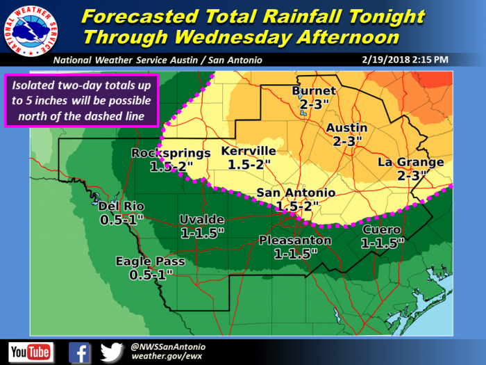
Tuesday Night/Wednesday: North of a line from Rocksprings to San Antonio to Hallettsville
Threats & Impacts:
Timing and Overview:
An unstable pattern will favor repeated rounds of showers and thunderstorms, beginning as early as late this evening and continuing into Wednesday afternoon. Threats for strong to severe storms and heavy rain tonight should be mainly north and west of a line from Burnet to Medina to Eagle Pass tonight before shifting east from late Tuesday through Wednesday afternoon when the main threat area will be north of a line from Rocksprings to San Antonio to Hallettsville. A cold front is expected during the day Wednesday with additional showers and thunderstorms expected behind the front for several hours.
LCRA Forecast
Bob Rose, chief meterologist for the Lower Colorado River Authority. Generally agrees. Here is an excerpt from his regular weather blog:
The weather pattern will be trending wet and unsettled over the next few days as a series of low pressure troughs move over our region out of the southwestern US. A recent change in the position of Jet Stream has allowed a large trough of low pressure to set up and stall over the western US. Over the next 1-2 weeks, disturbances moving through the western trough are forecast to eject east across Texas, producing periods of rain showers and scattered thunderstorms.
The combination of that developing low pressure trough over the western US and a broad ridge of high pressure over the western Atlantic is helping to steer a warm and very moist air mass into Texas. Midday satellite images showed clouds covering most of Central and South Texas, and these clouds will likely remain in place for most of the afternoon. Despite the clouds, afternoon temperatures will be quite mild, with highs generally in the mid and upper 70s. With atmospheric moisture levels increasing, there will be a slight chance for a few isolated rain showers and thunderstorms across the area, but widespread rain is not expected. It will be a breezy afternoon with southerly winds at 10-20 mph with occasional gusts to 30 mph.
The chance for rain and thunderstorms looks to increase across the Hill Country and Central Texas regions tonight when a vigorous trough of low pressure moves east out of northern Mexico. High-resolution forecast solutions call for a large complex of rain and thunderstorms to develop over northern Mexico and Far West Texas this evening, with the rain and storms spreading over the Hill Country before midnight and the Central Texas region shortly after midnight. The activity is forecast to continue overnight, tapering off from west to east after daybreak Tuesday. Should the rain and storms hold together, they will spread across the middle Texas coast Tuesday morning. Severe storms are not forecast but a couple of the thunderstorms may produce small hail and gusty winds. Rain amounts Monday night into Tuesday morning are forecast to generally be between 0.5 and 1 inch, with isolated heavier totals.
Low temperatures Tuesday morning will be in the mid-60s.
Forecasts call for the sky to remain cloudy Tuesday. Occasional rain showers and isolated thunderstorms will be possible throughout the day, with the probability for rain near 80 percent.


