

Central Texas watching the weather
Like us, follow us and see more maps on The Highlander page of Facebook: http://bit.ly/1MZW51U
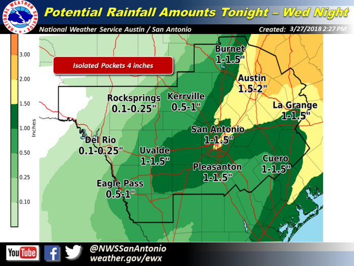
Burnet and surrounding counties do not look to be in the worst danger zone for strong to severe storms tonight through Wednesday across much of South Central Texas but, according to the National Weather Service, pockets of locally heavy rainfall are possible tonight through Wednesday morning.
Driving east could require a watchful eye on the weather.
This evening: Rio Grande Plains, Southern Edwards Plateau, Winter Garden regions.
Overnight tonight through Wednesday morning: Much of South Central Texas, especially I-35 corridor.
Threats & Impacts:
Hail: Isolated severe storms capable of producing quarter to golf ball sized hail.
Rainfall: 1-2 inches expected along and east of the I-35 corridor, with isolated totals up to 4 inches. Lesser amounts westward along the Rio Grande Plains.
Timing and Overview:
An upper level disturbance this evening and a cold front overnight into Wednesday will combine to produce showers and thunderstorms across much of South Central Texas. The best chances of storms in the evening will be across the Rio Grande Plains, southern Edwards Plateau, and Winter Garden region. The storms will expand in coverage overnight into the Hill Country, I-35 corridor, and east.
Overnight and into early Wednesday morning will see the heaviest rain and storms focused along the I-35 corridor. Showers and storms could decrease in coverage mid morning through early afternoon as conditions stabilize. Then an increase in showers and storms is possible again near and east of I-35 during the late afternoon and evening hours on Wednesday as the main cold front and upper disturbance moves through the region. Precipitation chances should end west to east late Wednesday night.
Some storms tonight through Wednesday evening could be strong to severe, with the main threats from these storms being large hail and damaging winds. A locally heavy rainfall threat is possible late tonight, especially along the I-35 corridor counties and eastward. Due to recent drought conditions the threat for widespread flash flooding should be limited. However, localized flooding is possible especially in urban areas should higher pockets of rainfall occur there.


