hail


Thu
19
May

Flash Flood Watch Issued for all of South Central Texas on Thursday (1 AM until 10 PM)

Article Image Alt Text

Area of Concern:

All of South Central Texas for flash flooding and subsequent river flooding, with a slight risk for severe storms and isolated tornadoes primarily in the Coastal Plains. See attached graphics.

Threats & Impacts:

Tornadoes:  A few tornadoes in the Coastal Plains possible, low risk elsewhere

Winds:  Up to 60 mph

Mon
16
May

Severe thunderstorms expected across South-Central Texas Tuesday afternoon, evening

Article Image Alt Text

Area of Concern:

All of south-central Texas, especially the Hill Country and I-35 corridor. 


Threats & Impacts:

Tornadoes:  Low threat for tornadoes.

Winds:  Wind gusts to 60 MPH.  

Hail: Up to 2 inches in diameter.

Rainfall: Localized amounts near 2 inches. 

Fri
29
Apr

Severe weather risk this afternoon, evening

Article Image Alt Text

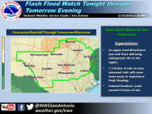
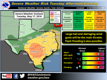
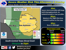
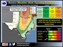
The Hill Country, including Burnet and Llano counties, is at risk for some severe storms this afternoon and evening. As you can see on the attached map, this includes areas across the eastern Hill Countgry as well as along and east of I-35, including Austin and San Antonio.

Threats include hail up to 2 inches in diameter as well as wind gusts of 60 to 70 mph and rainfall of between half an inch to 2 inches. Isolated pockets east of I-35 could see up to 4 inches of rain and an isolated tornado or two is possible.

Isolated to scattered showers will develop this morning with scattered thunderstorms developing in the afternoon and evening. Environmental conditions are favorable for some storms to become strong to severe and the severe threat may diminish after midnight.  

Mon
25
Apr

Weather alerts still on the map

Article Image Alt Text

Burnet and Llano counties are not in the target area for the worst weather this week, but stay alert if you are traveling north.

The National Weather Service issued a weather alert that is not leaving us out of the large hail and isolated strong storm threat.

Today, Monday April 25, we can expect to hit near 90 degrees and most likely tomorrow, to share a few of the showers.

Subscribe to RSS - hail