

Keep a weather eye out
The National Weather Service NWS does not forcast the worst of weather threats for Burnet County but strong to severe thunderstorms will be possible today and Friday with concerns shifting to primarily heavy rainfall over the weekend, possibly resulting in flash flooding.
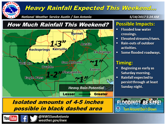
At least moderate threats fall along and west of the I-35 corridor, the worst of which would be hail up to 2 inches in diameter and straight line wind gusts exceeding 60 mph. Rainfall could add up to from 1-3 inches with isolated 4-5-inch amounts possible from 7 a.m. Saturday-7 a.m. Monday.
The NWS announcement says: "Multiple rounds of active weather are expected today through the weekend. Isolated strong to severe thunderstorms will be possible mainly along and west of the I-35 corridor this afternoon and evening, Friday morning, and possibly again Friday afternoon. Large hail is the primary concern with the severe weather episodes. However, damaging winds gusts will also be possible."
Saturday, a cold front passage will shift the concern from severe weather to heavy rainfall and potentially flash flooding. Heavy rainfall may begin as early as Saturday morning and persist through Sunday evening. Generally, 1-3 inches of rainfall are expected, but isolated amounts of 4-5 inches may occur.


