Burnet County weather


Thu
18
May

Keep a weather eye out

Article Image Alt Text

The National Weather Service NWS does not forcast the worst of weather threats for Burnet County but strong to severe thunderstorms will be possible today and Friday with concerns shifting to primarily heavy rainfall over the weekend, possibly resulting in flash flooding. 

At least moderate threats fall along and west of the I-35 corridor, the worst of which would be hail up to 2 inches in diameter and straight line wind gusts exceeding 60 mph. Rainfall could add up to from 1-3 inches with isolated 4-5-inch amounts possible from 7 a.m. Saturday-7 a.m. Monday.


Wed
25
May

Severe weather alert issued

Article Image Alt Text

Forecasts still hold out hopes for improvements for Saturday night, May 28, and the Memorial Day weekend. See more from the National Weather Service on Facebook: The-Highlander.

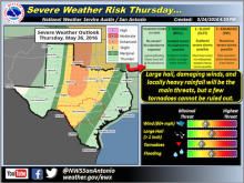
Gusty southerly winds are adding moisture and, while afternoon and evening thunderstorms are possible today, Wednesday, May 24, the threat is predicted to escalate and the National Weather Service (NWS) has issued severe weather alerts.

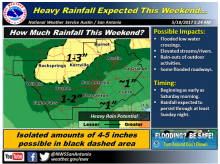
“The broad trough of low pressure over the western US is forecast to slowly shift to east Thursday through Friday, said Bob Rose, chief meteorologist for the Lower Colorado River Authority. “As the trough approaches northwestern Texas, it's expected to cause the widespread development of rain showers and thunderstorms across the Hill Country and Central Texas.”

Subscribe to RSS - Burnet County weather