

Look sharp: rains have arrived
Burnet County still is not in the target area for the heaviest rains over the next seven days, but with a mid-day downpour, the Highland Lakes clearly are heir to those "locally heavy rains" predicted this morning, Sept. 16.
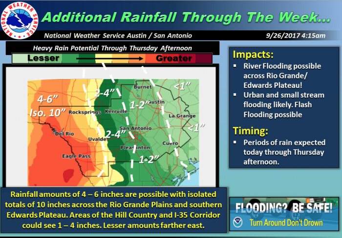
The National Weather Service says areas of localized heavy rainfall leading to flash and river flooding will be possible through Thursday afternoon with the highest likelihood near the Rio Grande Plains into the southern Edwards Plateau, along and west of US 83.
It must be stressed, says the NWS, that this will be a multi-round event and any time-frame through Thursday could have a local flash flooding risk due to repeating heavy rain cells.
Area of Concern:
Rio Grande Plains into the Southern Edwards Plateau and possibly into portions of the western Hill County. See Additional Rainfall Graphic below for more details.
Threats & Impacts:
Rainfall: 4 to 6 inches with locally higher amounts of 10 inches in the area of concern. There is a small likelihood that even highly localized higher amounts could be possible.
Flooding Impacts: Several locations may experience moderate flooding with flood waters capable of causing rivers and tributaries to become swollen and over-spill their banks. Small streams, creeks and ditches will overflow with some low lying structures flooded. Flood waters may prompt several evacuations and road closures, especially in normally flood-prone areas.
Timing and Overview:
A dissipated tropical storm from the Pacific combining with a slow-moving cold front and weak disturbance through mid-week will support heavy rainfall over multiple time periods through Thursday. Given the rocky soil in the expected highest rainfall total location, river and flash flooding is of particular concern.


