Burnet County still is not in the target area for the heaviest rains over the next seven days, but with a mid-day downpour, the Highland Lakes clearly are heir to those "locally heavy rains" predicted this morning, Sept. 16.
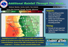
The National Weather Service says areas of localized heavy rainfall leading to flash and river flooding will be possible through Thursday afternoon with the highest likelihood near the Rio Grande Plains into the southern Edwards Plateau, along and west of US 83.
It must be stressed, says the NWS, that this will be a multi-round event and any time-frame through Thursday could have a local flash flooding risk due to repeating heavy rain cells.
Area of Concern:
Rio Grande Plains into the Southern Edwards Plateau and possibly into portions of the western Hill County. See Additional Rainfall Graphic below for more details.
Threats & Impacts: