

Burnet County, NWS, LCRA, PEC focus on winter storm warning
This story updated at 4:30 p.m. Monday, Jan. 15.
By Glynis Crawford Smith
The Highlander
Burnet County offices and many others across the region will be closed tomorrow it was announced this afternoon, as the National Weather Service, the Lower Colorado River Authority and the Pedernales Electric Cooperative continue today, Monday, Jan. 15, to expect severe winter weather to arrive soon.
Marble Falls city offices will not open until 10 a.m. tomorrow.
"Confidence continues to increase our region will see the development of widespread freezing precipitation beginning late tonight, continuing through late afternoon Tuesday as arctic air spreads south behind a cold front," said Bob Rose, LCRA chief meterologist.
He said, as of midday Monday, an arctic cold front was pushing south out of the Plains states and had moved just south of the Red River. The front is forecast to reach the northern Hill Country this evening and the Austin area around 10/11 pm. The front should push off the middle Texas coast a couple of hours before sunrise Tuesday. Conditions will turn breezy and much colder tonight following the cold front. Expect a north wind at 15-25 mph, with occasional gusts to 35 mph. Temperatures are forecast to fall below freezing about 3-4 hours behind the cold front. Low temperatures Tuesday morning will include the low and mid-20s across the Hill Country, the mid-20s across Central Texas with mid and upper 30s to the south of Interstate 10.
PEC line crews and staff members are preparing for severe winter weather beginning this evening through Wednesday, Jan 17. The cooperative is actively monitoring potential precipitation levels and dropping temperatures, focusing on the impact it may have on PEC members across its service territory.
"Meteorologists predict accumulating ice, snow and sleet will hit the Hill Country Monday evening, potentially lingering through midday Wednesday," said a Monday afternoon press release from the coop. "PEC line crews and contractor crews are on alert to be ready to respond to outages, and support staff will monitor PEC’s electric system 24/7.
"Report power outages by calling 888-883-3379. Members should consider saving this number in their mobile phone contacts. Members may also report outages online at pec.smarthub.coop or with their smart phone using the SmartHub app. Monitor power outages and find estimated restoration times at outages.pec.coop or by using the SmartHub app."
"Travel is discouraged during inclement weather, as many roadway surfaces will become slick and dangerous, potentially causing vehicle accidents," the PEC advisory continued. "Care for pets and outside plants by bringing them inside, as wind chill values in the single digits are possible across the Hill Country. Expect trees and utility lines to become ice and snow covered — if you see a downed power line, call 911 immediately and do not approach or touch the line."
"Forecasts indicate the Hill Country and the Austin/Central Texas regions could see ice accumulations up to a quarter inch from late Monday night through late Tuesday afternoon," said Rose. "This amount of ice will make travel very hazardous throughout the day Tuesday. With the temperature remaining below freezing Tuesday night into Wednesday morning, hazardous driving conditions will also continue Tuesday night into Wednesday morning. Across the coastal plains region, only very light ice accumulations are expected.
"Clouds are forecast to decrease Tuesday night and this will allow the temperature to become very cold! Low temperatures Wednesday morning will include the low and middle teens across the Hill Country, the upper teens across Central Texas and low to mid-20s across the Coastal Plains."
A partly cloudy sky is forecast Wednesday, but the temperature will remain very coldm according to Rose. For most locations, the temperature is not expected to rise above freezing until late morning or noon.
"This means the ice from Tuesday won’t begin to melt until about midday," he said. "High temperatures Wednesday will generally only be in the mid and upper 30s.
Low temperatures Thursday morning will include the low 20s Hill Country, the mid-20s Central Texas and around 28-30 degrees across the Coastal Plains.
Due to the potential of inclement weather, PEC’s regularly scheduled Board of Director’s meeting on Tuesday, Jan. 16 has been canceled. The meeting has been rescheduled for Jan. 19 (time to be determined).
Due to the high probability for freezing rain in Central Texas, LCRA will close its offices on Tuesday, and will hold the LCRA Board and committee meetings on Wednesday, Jan. 17.
The Monday National Weather Service report is as follows:
Area of Concern:
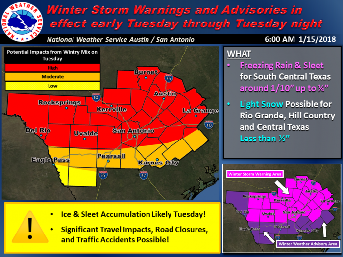
- Freezing Rain and Sleet: All of South-Central Texas. Potential for greatest accumulation will be in the Winter Weather Warning area that includes Burnet, Llano and Blanco Counties (see attached map).
- Sleet and Snow: Hill Country, southern Edwards Plateau, and portions of the Rio Grande (near and north of a Del Rio to Medina to San Marcos to Giddings line)
Expected Accumulations:
- Freezing Rain & Sleet: A few hundredths of an inch to 1/10 of an inch of freezing rain and sleet accumulation is expected with up to 1/4 of an inch possible.
- Snow: Less than 1/2 inch
Temperatures and Wind Chills:
- Air temperature dropping into the mid 20s to low 30s by noon Tuesday for much of the area.
- 25-35 mph wind gusts will produce Wind Chill values Tuesday in the teens to mid 20s. Some single digit wind chill values in the single digits are possible across the Hill Country
- Low temperatures Wednesday morning in the upper teens to upper 20s
Impacts: Travel is discouraged Tuesday in the Winter Storm Warning area as many roadway surfaces will become slick and dangerous potentially causing vehicle accidents. Exposed outdoor objects, including trees, utility lines, and vehicles will become ice and snow covered. Isolated power outages are possible.
A hard freeze will have a significant impacts on sensitive plants and pets. Elderly persons or young children could suffer hyperthermia if exposed to long duration of extremely cold temperatures. Exposed water pipes could break.
Timing and Overview:
Tonight Through Tuesday Evening: Confidence continues to increase this morning on a significant winter weather event set to start late tonight and persist through Tuesday Evening. A strong, arctic cold front will move into the Hill Country and southern Edwards Plateau around midnight tonight and through southern areas of the region near sunrise Tuesday morning. Temperatures will plummet behind the front, falling by late Tuesday morning into the mid to upper 20s across the Hill Country and southern Edwards Plateau and upper 20s to low 30s elsewhere.
Most models are indicating the potential for freezing rain and sleet behind the front, beginning across the Hill Country and southern Edwards Plateau, including Austin, between 12AM tonight and 6 AM on Tuesday and for the remaining southern areas, including San Antonio, between 3 AM and 9 AM Tuesday and south of Highway 90 between 9 AM and 6 PM. A changeover to light snow could occur across portions of the Rio Grande, southern Edwards Plateau and Hill Country, including Austin, before precipitation ends Tuesday evening.
This has the potential to become a more significant winter weather event, than just the traditional bridges and overpasses. Given the forecast temperatures in the mid 20s to around 30. Around 1/10 of an inch of ice is generally expected, however pockets up to 1/4 of an inch of ice are possible. Snow amounts, should it occur, are currently forecast to remain less than 1/2 inch.
A Winter Storm Warning has been issued for most of the northern part of south central Texas. Preparations should be ongoing now with an expectation for significant travel impacts.
Wednesday Night through Thursday Morning:
Finally, models continue to advertise another possible winter weather event Wednesday night through Thursday morning, with the potential for a wintry mix of accumulations. Details on locations and impacts with this event are currently low to moderate. We will update you further in the coming days on this potential as confidence increases.
National Weather Service Confidence:
- Cold Air: Very High
- Freezing Rain and Sleet: Moderate to High
- Snow: Low to Moderate
- Travel Impacts: Moderate to High


