weather alert


Mon
15
Jan

Burnet County, NWS, LCRA, PEC focus on winter storm warning

Article Image Alt Text

This story updated at 4:30 p.m. Monday, Jan. 15.

By Glynis Crawford Smith

The Highlander

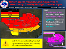
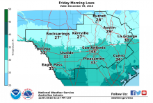
Burnet County offices and many others across the region will be closed tomorrow it was announced this afternoon, as the National Weather Service, the Lower Colorado River Authority and the Pedernales Electric Cooperative continue today, Monday, Jan. 15, to expect severe winter weather to arrive soon.

Marble Falls city offices will not open until 10 a.m. tomorrow.

"Confidence continues to increase our region will see the development of widespread freezing precipitation beginning late tonight, continuing through late afternoon Tuesday as arctic air spreads south behind a cold front," said Bob Rose, LCRA chief meterologist.

Tue
23
May

Slight risk for severe thunderstorms headed this way

Article Image Alt Text
The risk is slight but the National Weather Service warns new bands of storms are headed across most of South Central Texas, including local and western counties, extending to the Austin and San Antonio metro areas.

Worst of the threats are hail up to golf ball size and straight line wind gusts up to 60 mph and worth noting for travelers.

Mon
10
Apr

Rain chances increasing, watch for flash flooding

Article Image Alt Text

The National Weather Service (NWS) issued a notice Monday morning, April 10, with an advisory for locally heavy rainfall possibility over portions of South Central Texas late this afternoon through Tuesday.

 The greatest risk, said the NWS, is across the Hill Country and into the I-35 corridor (including both Austin and San Antonio metro areas). It is also possible for some of the higher rainfall totals to extend into parts of the southern Edwards Plateau and Rio Grande.

Rainfall of 1-3 inches is possible across that area, with isolated pockets of 5-7 inches. Some locations could experience flash flooding of small streams, creeks, and low water crossings. The rainfall could result in localized minor to moderate river flooding.

Tue
28
Mar

Keep a weather eye on incoming storm system

Article Image Alt Text

A National Weather Service severe weather risk map shows Burnet County in the center of the area vulnerable to an approaching storm front. See The Highlander page on Facebook for maps of the timing of that approach.

The National Weather Service (NWS) has issued a notice of severe storms possible this evening through early Wednesday, March 29.

All of South Central Texas, but this time primarily near the I-35 corridor west to the Rio Grande.

Straight-line wind gusts up to 70 mph, hail up to 2 inches in diameter and isolated tornadoes are possible. Rainfall up to two inches in some areas are possible across the Hill Country.

Timing and Overview

Fri
20
Jan

Windy weekend weather a fire hazard

Article Image Alt Text

The National Weather Service (NWS) is warning all South Central Texas of northwest winds that could reach sustained levels of 30 miles per hour, gusts up to 45 miles per hour.
Strong winds alone could cause minor damage and isolated power outages.
With Sunday humidity between 20-30 percent, fires could spread quickly.  
The NWS alert says:
A weather system to our north will cause strong and gusty Northwest winds starting Saturday night and lasting through Sunday evening.  
The strongest winds, with gusts maybe exceeding 45 mph, will likely occur Sunday afternoon.  
Along with the wind, relative humidity will drop below 20 percent out west near the Rio Grande...and below 30 percent elsewhere.  This wind and low humidity will increase the threat for fast moving fires.

Wed
07
Dec

NWS issues alert for high winds, low temps

Article Image Alt Text

Cover those plants and watch out for the pets. The National Weather Service has issued an alert for high winds and freezing temperatures.

An arctic cold front will move through South Central Texas late tonight, Wednesday, Dec. 7. Much colder conditions will occur Thursday through Friday, along with windy conditions Thursday. A freeze is expected across portions of the area Thursday night into Friday morning.

A hard freeze is possible across the Hill Country and portions of Central Texas with a light freeze along the I-35 corridor and east. The winds will make temperatures feel much colder Thursday and Thursday night.

Fri
02
Dec

NWS cautions rain events east of I-35

Article Image Alt Text

In response to possible rain, The City of Granite Shoals has cancelled the Christmas by the Highway lighting ceremony tonight, Friday, Dec. 2. The Walkway of Lights in Marble Falls does not admit visitors when it is raining, but a decision about tonight will not be made until 2:30 p.m. The toll free number for advisories about the Walkway is 844-MFLIGHTS (844-635-4448).

The National Weather Service has issued a warning for along and East of I-35, where area-wide showers may concentrate into 2-5 inches with isolated downpours of more than 6 inches possible.

An upper level low pressure system will move slowly across northern Mexico and Texas today through Monday, with persistent rains expected through the period.

Most of the rain is expected to be light to moderate today through Sunday with some brief heavy downpours of 1 to 2 inches possible Saturday morning through Sunday afternoon. 

The storm system could produce more widespread heavy downpours Sunday night into early Monday as the upper low begins to cross Texas.  Soil moisture conditions are not expected to be conducive to flooding initially, but there is a potential for flooding by Sunday night. Areas generally east of I-35 are expected to see the heaviest rainfall and possible flooding.

Tue
31
May

Burnet County braces for more storms

Article Image Alt Text

In addition the National Weather Service has placed the area on a Flash Flood Watch. http://bit.ly/1Y1eH4m

BY ALEXANDRIA RANDOLPH/HIGHLAND LAKES NEWSPAPERS

Storms on Tuesday afternoon are the first of a series of storms this week, meteorologists said.

The National Weather service has issued multiple hazard statements for the Burnet County area, which a forecast of storms all through the week. The City of Marble Falls issued an alert at 5:24 p.m. today, May 31, that Lake Marble Falls is closed until further notice due to flood gate operations and the City of Horseshoe Bay issued multiple low water crossing closings throughout the afternoon.

A flood advisory was issued at 2:15 p.m. on Tuesday, May 31 for southwestern Burnet County, southeastern Llano County and surrounding counties, effective until 5:15 p.m.

Mon
25
Apr

Weather alerts still on the map

Article Image Alt Text

Burnet and Llano counties are not in the target area for the worst weather this week, but stay alert if you are traveling north.

The National Weather Service issued a weather alert that is not leaving us out of the large hail and isolated strong storm threat.

Today, Monday April 25, we can expect to hit near 90 degrees and most likely tomorrow, to share a few of the showers.

Sun
17
Apr

Latest weather alert reported

Article Image Alt Text

This map accompanied the National Weather Service alert issued Saturday, April 16.

The National Weather Service on Saturday, April 16, issued the alert for a slow-moving storm system with the threat of locally heavy rainfall across South Central Texas Sunday afternoon through Tuesday morning.
All of South Central Texas, with the heaviest rainfall expected primarily along and east of a Fredericksburg to Pearsall line, including both the San Antonio and Austin metro areas.
Rainfall with 48-hour hour totals during that time span in a widespread could be 3-6 inches with isolated 7-10 inch totals possible for areas east-northeast of a Fredericksburg to Pearsall line. Lesser amounts of 1-3 inches are expected elsewhere.
Flashflood and river flooding are the primary concern. Although it will be secondary to the heavy rainfall and flash flooding threat, isolated damaging winds and isolated brief tornadoes will be possible. The threat for large hail is low.
Subscribe to RSS - weather alert