The National Weather service has issued a new Flash Flood Watch in effect for All of South Central Texas through at least Thursday morning due to oncoming heavy rainfall.
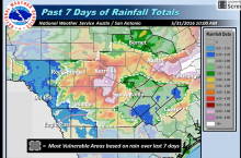
Particularly of concern are areas that have seen significant rainfall over the past week. Widespread additional rainfall in amounts of from 3-6 inches, with a few locations of up to 10 inches, is predicted.
Several locations may experience major flooding with flood waters capable of causing rivers and tributaries to overflow their banks in several places. Small streams, creeks, canals, and ditches become dangerous rivers with flood waters spreading well away from the banks. Widespread inundation of both primary and secondary roads with some long term closures is possible.