A National Weather Service Flash Flood Watch continues for most of South Central Texas from 10 a.m. Sunday to 10 a.m. Tuesday.
All of South Central Texas is included, with the heaviest rainfall expected primarily along and east of U.S. 281 and along and north of Interstate 10. This still includes both the San Antonio and Austin metro areas.
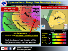
Over the next 48 hours and widespread, 3-6 inches of rain are expected over most of South Central Texas with isolated amounts of 8-12 inches mainly east of U.S. 281 and north of Interstate 10.
Flash floods and river flooding remain the primary concern. Rising levels on rivers, creeks, and streams and increasing soil moisture levels will continue to increase this threat over the 48 hour period ending Tuesday morning.