

Sunday weather alert issued
Submitted by highlander1 on
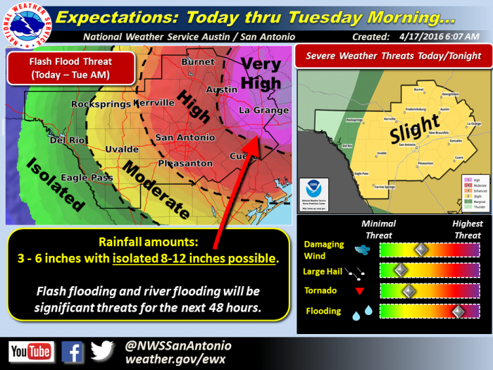
A National Weather Service Flash Flood Watch continues for most of South Central Texas from 10 a.m. Sunday to 10 a.m. Tuesday.
All of South Central Texas is included, with the heaviest rainfall expected primarily along and east of U.S. 281 and along and north of Interstate 10. This still includes both the San Antonio and Austin metro areas.
Over the next 48 hours and widespread, 3-6 inches of rain are expected over most of South Central Texas with isolated amounts of 8-12 inches mainly east of U.S. 281 and north of Interstate 10.
Flash floods and river flooding remain the primary concern. Rising levels on rivers, creeks, and streams and increasing soil moisture levels will continue to increase this threat over the 48 hour period ending Tuesday morning.
Although it will be secondary to the heavy rainfall and flash flooding threat, isolated damaging winds and isolated brief tornadoes will be possible, particularly Sunday afternoon and evening. The threat for large hail is relatively low. Another threat for severe weather is also expected on Monday, mainly for areas south of a Del Rio to New Braunfels line.
The upper level low over the the southwestern United States will produce chances for multiple rounds of showers and thunderstorms Sunday through Tuesday. Locally heavy rainfall and severe weather will be a concern across South Central Texas Sunday afternoon through Tuesday morning. The first round is expected to begin late Sunday morning and lasting into the evening as a stalled surface boundary helps provide an additional focus for storms. At least one more round of storms is expected on Monday, but the timing of storms and their impacts will depend upon what happens on Sunday.
As part of the current weather pattern, heavy snowfall is expected in the Rocky Mountains.
Rate this article:


