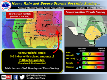
The National Weather Service on Saturday, April 16, issued the alert for a slow-moving storm system with the threat of locally heavy rainfall across South Central Texas Sunday afternoon through Tuesday morning.
All of South Central Texas, with the heaviest rainfall expected primarily along and east of a Fredericksburg to Pearsall line, including both the San Antonio and Austin metro areas.
Rainfall with 48-hour hour totals during that time span in a widespread could be 3-6 inches with isolated 7-10 inch totals possible for areas east-northeast of a Fredericksburg to Pearsall line. Lesser amounts of 1-3 inches are expected elsewhere.
Flashflood and river flooding are the primary concern. Although it will be secondary to the heavy rainfall and flash flooding threat, isolated damaging winds and isolated brief tornadoes will be possible. The threat for large hail is low.