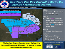
National Weather Service


Fri
15
May

Severe storms predicted Friday, Saturday in the Highland Lakes

From staff reports

The National Weather Service is reporting with increasing confidence that areas of Burnet County could receive between 2-4 inches of rain and possibly up to golfball-sized hail from a strong to severe storm expected to hit the Hill Country on Friday, May 15.

Fri
01
Mar

National Weather Service teaches weather spotting with Skywarn

From staff reports

The National Weather Service, Austin/San Antonio forecast office will host a training event to help educate the public on how to decipher and report severe weather events.

Skywarn and FloodAware Seminar will be be presented by NWS and sponsored by the Burnet County Office of Emergency Management.

Topics will include instructions on submitting severe weather reports; how to identify the various weather events as they unfold; the appropriate terminology for specific weather phenomenon; and safety guidelines if caught in the midst of severe weather.

The training program is scheduled from 6 p.m. to 9 p.m. on Tuesday, March 5, 2019 at the Texas A&M Agrilife Extension Office, 607 N. Vanderveer in Burnet. The event is free and open to the public.

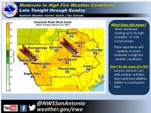
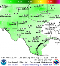
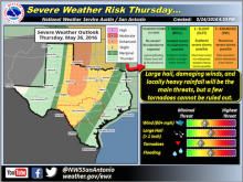
For more information, go to weather.gov/ewx.

Tue
02
Jan

Caution advised for southern travel

Article Image Alt Text

The National Weather Service is continuing its travel advisory just south of the Highland Lakes for in this New Year's Day communique.

...Light Wintry Precipitation Continues Today...

...Prolonged sub-freezing temperatures for much of the area through Wednesday morning...

Area of Concern:

Wintry Precipitation: Rio Grande Plains, Southern Edwards Plateau, portions of the I-35 corridor generally south of New Braunfels

Sub-Freezing Temperatures: All of south central Texas.

Threats & Impacts:

Tue
05
Dec

Wintry Mix Likely for Hill Country Wednesday afternoon-Thursday morning

Article Image Alt Text
The National Weather Service has issued a Wintry Precipitation alert---That's snow folks.

The percipitation is expected for portions of the Hill Country and the southern Edwards Plateau Wednesday afternoon through early Thursday morning.

Area of Concern:

Hill Country and the southern Edwards Plateau

Threats & Impacts:

Rain/Snow Mix: A mix of rain and snow is likely Wednesday afternoon into Thursday morning across the Hill Country and southern Edwards Plateau, primarily north and west of a Comstock to Comfort to Georgetown line.

Mon
28
Aug

Harvey hightailing it from Highland Lakes

Article Image Alt Text

The 5 a.m. radar image shows the worst of the storm moving away. More information can be found at www.weather.gov and more images from the Monday report, on The-Highlander Facebook page.

The Monday morning storm report from the National Weather Service (NWS) shows Burnet and Llano counties high and dry and a reprieve from more heavy rainfall for neighbors just to the south.

The local forecast includes a 50 percent chance of showers and gusty winds remains, improving throughout the week . Dangers for travel to the hardest hit areas remains, however.

The NWS 5 a.m. Monday, Aug.28 storm report says: Tropical Storm Harvey continues a slow drift back to the southeast and will continue southeast and emerge just offshore of the middle Texas coast Monday afternoon.

Mon
07
Aug

Local counties recorded highest rainfall

Article Image Alt Text

A National Weather Service forecast shows small chances for showers as skies clear and temperatures climb for LakeFest weekend in MarbleFalls.

The National Weather Service (NWS) says more showers, less flooding for our area, but it did come down from late Sunday night to Monday morning, Aug. 6-7.

The storm cluster over north Texas moved south and produced widely varying rain totals, heaviest in portions of Llano and Burnet Counties, where as much as 5-8 inches fell. Some flash flooding was observed in this area but recent dry conditions have helped limit the overall flooding and flash flooding threat, according to the NWS. “LCRA opened one floodgate at Wirtz Dam and one floodgate at Starcke Dam to move floodwaters downstream early Monday morning. Both gates were closed by 11 a.m.”

Sun
22
Jan

Fire Weather Watch issued

Article Image Alt Text

The National Weather Service has issued a Fire Weather Watch.

A potent weather system to our north is pushing the strong and gusty northwest winds that began late last night and promise to persist through Sunday afternoon. The strongest winds, with gusts to around 45 mph, will occur during the day on Sunday. Along with the wind, relative humidity will drop below 20% out west near the Rio Grande Sunday afternoon and and below 35% elsewhere.  This wind threat alone will be enough to carry fire quickly, especially in wildland grasses that are cured for the winter. A Fire Weather Watch has been issued for all of South Central Texas, and some locations could be upgraded to a Red Flag Warning.

The high wind could also result in hazardous driving conditions for high profile vehicles, displace loose objects, result in minor property damage, and cause isolated power outages.

The NWS forecast for Marble Falls and surrounding area:

Wed
31
Aug

Chance of rain tonight and tomorrow

Article Image Alt Text

Contributed/National Weather Service

BY ALEXANDRIA RANDOLPH

The National Weather Service Austin/San Antonio has issued a short term forecast for showers and thunderstorms this afternoon.

In the forecast issued at 3:02 p.m. Wednesday, Aug. 31, meteorologists said “isolated showers and thunderstorms will move toward the west… These showers will produce light to moderate rain with rainfall totals up to a half an inch.”

The forecast is active through 5 p.m. Wednesday evening. Chance of rain will remain at 20 percent until Thursday at 8 p.m. On Friday, chance of rain increases to 30 percent between 8 a.m. and 8 p.m.


Wed
25
May

Severe weather alert issued

Article Image Alt Text

Forecasts still hold out hopes for improvements for Saturday night, May 28, and the Memorial Day weekend. See more from the National Weather Service on Facebook: The-Highlander.

Gusty southerly winds are adding moisture and, while afternoon and evening thunderstorms are possible today, Wednesday, May 24, the threat is predicted to escalate and the National Weather Service (NWS) has issued severe weather alerts.

“The broad trough of low pressure over the western US is forecast to slowly shift to east Thursday through Friday, said Bob Rose, chief meteorologist for the Lower Colorado River Authority. “As the trough approaches northwestern Texas, it's expected to cause the widespread development of rain showers and thunderstorms across the Hill Country and Central Texas.”

Wed
18
May

Hazardous Weather Outlook issued

Article Image Alt Text
Burnet, Llano and surrounding counties are included in a Hazardous Weather Outlook and Flash Flood Watch from the National Weather Service Austin/San Antonio office for Wednesday, May 18:
This afternoon and tonight: a line of storms should develop across the western areas overnight. The main hazard with this activity is the potential for heavy rainfall. a flash flood watch is in effect beginning at 1 a.m.

Pages

Subscribe to RSS - National Weather Service