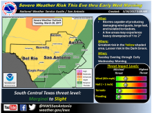
The National Weather Service (NWS) has issued a notice of severe storms possible this evening through early Wednesday, March 29.
All of South Central Texas, but this time primarily near the I-35 corridor west to the Rio Grande.
Straight-line wind gusts up to 70 mph, hail up to 2 inches in diameter and isolated tornadoes are possible. Rainfall up to two inches in some areas are possible across the Hill Country.
Timing and Overview