

Keep a weather eye on incoming storm system
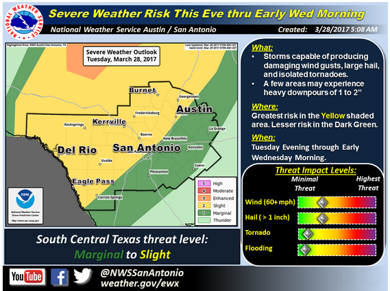
A National Weather Service severe weather risk map shows Burnet County in the center of the area vulnerable to an approaching storm front. See The Highlander page on Facebook for maps of the timing of that approach.
The National Weather Service (NWS) has issued a notice of severe storms possible this evening through early Wednesday, March 29.
All of South Central Texas, but this time primarily near the I-35 corridor west to the Rio Grande.
Straight-line wind gusts up to 70 mph, hail up to 2 inches in diameter and isolated tornadoes are possible. Rainfall up to two inches in some areas are possible across the Hill Country.
Timing and Overview
The NWS said the storm system will bring the best chance of showers and storms in the region tonight. Conditions will be favorable for some storms to become severe, with the primary threats being damaging straight-line wind gusts and large hail. A lesser, but non-zero, threat for isolated tornadoes will exist. Some isolated pockets of heavy downpours are possible, however due to the speed of the system significant flash flooding impacts are not anticipated at this time.
The storms are expected to develop across West Texas and the southern Edwards Plateau by early this evening. The storms may organize into a broken line that will move through the Hill Country late this evening, and into the I-35 corridor between midnight and 6 a.m. Wednesday. The storms will continue east of the I-35 corridor Wednesday morning, however some models indicate a weakening trend during that time.


