rainfall


Mon
07
Aug

Local counties recorded highest rainfall

Article Image Alt Text

A National Weather Service forecast shows small chances for showers as skies clear and temperatures climb for LakeFest weekend in MarbleFalls.

The National Weather Service (NWS) says more showers, less flooding for our area, but it did come down from late Sunday night to Monday morning, Aug. 6-7.

The storm cluster over north Texas moved south and produced widely varying rain totals, heaviest in portions of Llano and Burnet Counties, where as much as 5-8 inches fell. Some flash flooding was observed in this area but recent dry conditions have helped limit the overall flooding and flash flooding threat, according to the NWS. “LCRA opened one floodgate at Wirtz Dam and one floodgate at Starcke Dam to move floodwaters downstream early Monday morning. Both gates were closed by 11 a.m.”

Mon
10
Apr

Rain chances increasing, watch for flash flooding

Article Image Alt Text

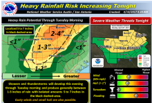
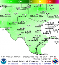
The National Weather Service (NWS) issued a notice Monday morning, April 10, with an advisory for locally heavy rainfall possibility over portions of South Central Texas late this afternoon through Tuesday.

 The greatest risk, said the NWS, is across the Hill Country and into the I-35 corridor (including both Austin and San Antonio metro areas). It is also possible for some of the higher rainfall totals to extend into parts of the southern Edwards Plateau and Rio Grande.

Rainfall of 1-3 inches is possible across that area, with isolated pockets of 5-7 inches. Some locations could experience flash flooding of small streams, creeks, and low water crossings. The rainfall could result in localized minor to moderate river flooding.

Wed
31
Aug

Chance of rain tonight and tomorrow

Article Image Alt Text

Contributed/National Weather Service

BY ALEXANDRIA RANDOLPH

The National Weather Service Austin/San Antonio has issued a short term forecast for showers and thunderstorms this afternoon.

In the forecast issued at 3:02 p.m. Wednesday, Aug. 31, meteorologists said “isolated showers and thunderstorms will move toward the west… These showers will produce light to moderate rain with rainfall totals up to a half an inch.”

The forecast is active through 5 p.m. Wednesday evening. Chance of rain will remain at 20 percent until Thursday at 8 p.m. On Friday, chance of rain increases to 30 percent between 8 a.m. and 8 p.m.


Subscribe to RSS - rainfall