

Rain chances increasing, watch for flash flooding
The National Weather Service (NWS) issued a notice Monday morning, April 10, with an advisory for locally heavy rainfall possibility over portions of South Central Texas late this afternoon through Tuesday.
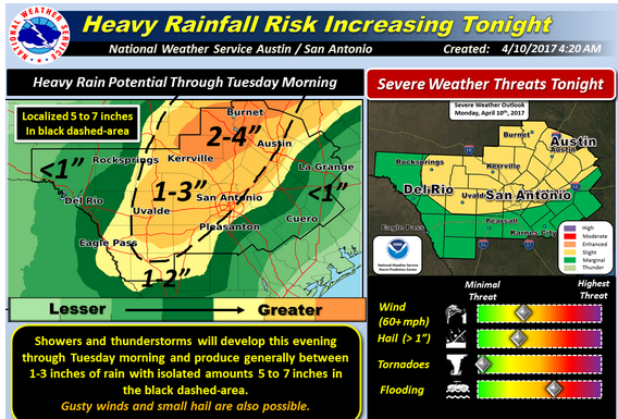
The greatest risk, said the NWS, is across the Hill Country and into the I-35 corridor (including both Austin and San Antonio metro areas). It is also possible for some of the higher rainfall totals to extend into parts of the southern Edwards Plateau and Rio Grande.
Rainfall of 1-3 inches is possible across that area, with isolated pockets of 5-7 inches. Some locations could experience flash flooding of small streams, creeks, and low water crossings. The rainfall could result in localized minor to moderate river flooding.
A cold front will interact with abundant moisture to produce the high chance for showers and storms across the region late this afternoon through Tuesday morning. NWS confidence has increased on higher rainfall amounts and timing of heaviest rain as latest Hi-Res models are in fair agreement on the potential for locally heavy rain. The time frame for heaviest rain is expected to occur from 7 p.m. this evening through 7 a.m. Tuesday.
Burnet, Blanco and Llano counties are in the 2-4 inch probability sector.


