flash flooding


Wed
10
Oct

Llano River flood water surge in Kingsland, LCRA opens flood gates in the Highland Lakes

Article Image Alt Text

Connie Swinney/The Highlander
Kingsland residents Ben Salazar and Dianna Hardesty checked out flooding at the Kingsland Slab Tuesday (Oct. 9) as rushing flood waters in the Llano River made their way from the Junction area through the Highland Lakes. Authorities reported no swiftwater rescues or injuries in Llano or Burnet counties.


Connie Swinney •
Staff Writer •

As the surge of the Llano River subsided, Highland Lakes residents and property owners reported minimal damage Oct. 9 and 10 to lakeside structures as well as some rising water along shorelines inching onto property.

Murky floodwaters from the Llano River from the Junction area crested in Kingsland after midnight just 24 hours earlier, eventually making its way through lakes LBJ and Marble Falls – to be captured in Lake Travis, just west of Austin.

On Oct. 10, the Lower Colorado River Authority reported floodgate operations on Wirtz and Starcke dams to pass floodwaters downstream.

Tue
11
Sep

Flash flooding sweeps through Backbone Creek in Marble Falls

Article Image Alt Text

Phil Reynolds/The Highlander

Torrential rain and thunderstorms sent runoff down Backbone Creek, resulting in flash flooding in Johnson Park in Marble Falls.


From staff reports •

Storm runoff caused a scare among some Pecan Valley and Meadowlakes residents Sept.8 and 9, as motorists were temporarily blocked from leaving their neighborhoods to avoid a flooded low-water crossing on Avenue N and a rain-swollen Backbone Creek crossing in Johnson Park in Marble Falls.

Residents reported the rise of the creek starting Saturday and subsiding throughout the day until another round of of storms swept through the area on Sunday.

“Avenue N on Saturday and Sunday was closed for some time because of water over the road,” Marble Falls Fire Rescue Chief Russell Sander said. “Johnson Park did have water over the bridge on Sunday.

Everything was temporary,” he added.

From more than 5 inches of rain in Marble Falls to nearly 4 inches in Spicewood were reported due to torrential thunderstorms and steady rain.

Mon
10
Apr

Rain chances increasing, watch for flash flooding

Article Image Alt Text

The National Weather Service (NWS) issued a notice Monday morning, April 10, with an advisory for locally heavy rainfall possibility over portions of South Central Texas late this afternoon through Tuesday.

 The greatest risk, said the NWS, is across the Hill Country and into the I-35 corridor (including both Austin and San Antonio metro areas). It is also possible for some of the higher rainfall totals to extend into parts of the southern Edwards Plateau and Rio Grande.

Rainfall of 1-3 inches is possible across that area, with isolated pockets of 5-7 inches. Some locations could experience flash flooding of small streams, creeks, and low water crossings. The rainfall could result in localized minor to moderate river flooding.

Thu
19
May

Storm rolls into Burnet County

Article Image Alt Text

A thunderstorm rolls into Burnet County Wednesday evening as seen across Lake Marble Falls. The county is under flash flood watch Thursday, May 19, until 10 p.m.

BY ALEXANDRIA RANDOLPH/BURNET BULLETIN

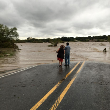
The Highland Lakes area is under a flash flood watch until Thursday at 10 p.m.

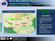
The National Weather Service Austin/San Antonio issued a flash flood watch for Llano, Burnet, Williamson, Blanco, Travis and a number of surrounding counties early Thursday morning.

Meteorologists stated that the watch continues for all of south Central Texas.

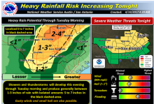
“Locally heavy rainfall is expected for much of today and early evening as an upper level disturbance pushes across the area and interact with a surface stationary boundary just to the south of highway 90. One to three inches of rainfall are expected over already saturated grounds due to recent heavy rain episodes. Flash flooding is possible.”

The major concern is runoff from highly saturated ground.

“Soils are already very saturated and most of the rain will runoff into area creeks, streams and low lying areas,” the watch read.

Thu
19
May

Flash Flood Watch Issued for all of South Central Texas on Thursday (1 AM until 10 PM)

Article Image Alt Text

Area of Concern:

All of South Central Texas for flash flooding and subsequent river flooding, with a slight risk for severe storms and isolated tornadoes primarily in the Coastal Plains. See attached graphics.

Threats & Impacts:

Tornadoes:  A few tornadoes in the Coastal Plains possible, low risk elsewhere

Winds:  Up to 60 mph

Subscribe to RSS - flash flooding